
This circular route explores the hills south of Loja. The route is 9.41 km long, has an elevation of 308 m and takes approximately 3.5 hours to complete.
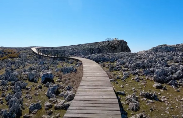
The route starts by walking up to the Charco del Negro, a beautiful wetland set among the rocks, where we might spot the sharp-ribbed newt. We follow the main path, with its wide views across the Málaga mountain ranges. We then come to the Cueva Horada, and from inside the cave walls form the perfect frame for the surrounding mountains. We then walk along the lane, passing the rock faces of the via ferrata and the pools at Fuente Alta. From here, we leave the track for a path on the left and make our way through a small ravine toward the Cueva de las Cabras. We skirt round the rock face to the spectacular Sierra Gorda lapiaz. We walk across this other-worldly landscape on a winding walkway to the viewpoint. The rest of the route follows the wind farm track, where we have the option to climb the Cerro de las Cabras for views over the valley, before making our way back through the karst formations and sinkholes to the starting point.
Note: The meeting point for this walk is the Abades service station. It is 12km along a non asphalt road. In April 2026 the road is in good condition and any type of car is OK. A 4x4 is not necesary
| Distance | 9.413 km |
| Duration | 2 hours 51 minutes GPX ------ 3 hours 7 mins (Naismith) |
| Total Climb | 308 m |
| Highest Point | 1637 m |
| Weather Link | Click here |
Meeting Point: Loja: Abades Service Area
LINK 1: More photos
See map full screen Click here
Note: You can choose different types of maps using the drop down (top right) EG ArcGis Ariel is satelliteDownload GPX file We give you permission to download the gpx file of this route and follow it on your smartphone. Please note that we own the copyright to this file and you cannot upload it somewhere else in the same way that you can't copy a Beatles song and then claim that you made it. Click here if you would like to know more about copyright of internet content.
This page has been seen 505 times since - 18th April 2026