
Route length: 8.5 km Estimated duration: 3 h 30 m Starting altitude: 2,030 m Maximum altitude reached: 2,613 m Maximum positive slope: 605 m. It is the highest point in the province of Almeria, there is a panoramic view from the top.
This is a great walk in August when it is very hot down below. It is so high that you notice the lack of oxygen as you get towards the summit. The views are incredible.
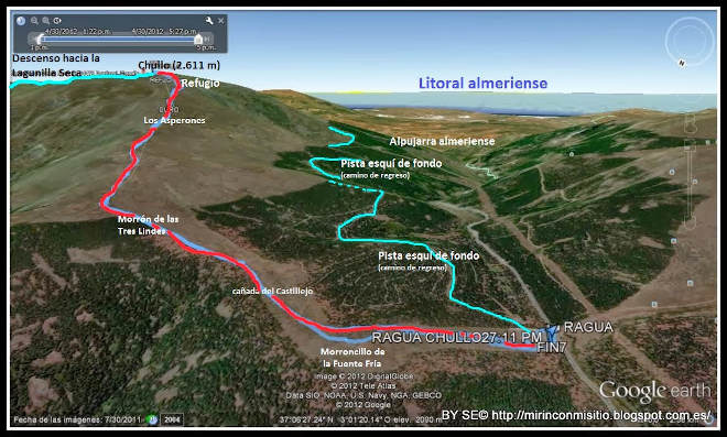
The starting point, Puerta de la Ragua, is better known for winter sports such as cross country skiing in the winter but in the summer it is a good place to climb to a high altitude to enjoy the cool temperatures. This route climbs the Chullo mountain which is 2,613 meters of altitude and the highest point in the province of Almeria. It is easily accessible and is an easy climb. From the summit there is a wonderful panoramic view: To the south, the Sierras de Gádor, Contraviesa and Lújar, behind them the Mediterranean; below is , the Alpujarra. To the west Mulhacén, Alcazaba, Cerro Pelado and Picón de Jeres. To the north, the plains of the Marquesado, the Hoya de Guadix, the Sierra de Baza and, in the background, Cazorla, the Sagra and Segura. To the east, the line of peaks of the Sierra Nevada Almeriense, with the Cerro del Almirez in the foreground.
We did this route in August when it is very hot in Granada. Someone said "How can you stand the heat? You are brave!" But it is the opposite, above 2000 meters the temperature is very pleasant even in August. Here is the explanation: The temperature decreases approximately one degree every 154 meters. Temperature decreases as altitude increases because air pressure also decreases with altitude, when air pressure decreases so does its density causing a drop in temperature. Also Humidity is lower at higher altitudes. Sweat evaporates quickly and cools you down faster.
Mountain tops from El Chullo The Summit of El Chullo Going up el Chullo Puerta de la Pagua
| Distance | 8.34 km |
| Duration | 3 hours 8 minutes GPX ------ 3 hours 32 mins (Naismith) |
| Total Climb | 580 m |
| Highest Point | 2608 m |
| Weather Link | Click here |
Meeting Point: Puerto de La Ragua
See map full screen Click here
Note: You can choose different types of maps using the drop down (top right) EG ArcGis Ariel is satelliteSorry we do not allow download of the gpx file of this walk because our group suffered a takeover by the weasly walkers. Click here if you would like to know what a walking group takeover is.
This page has been seen 3456 times since - 22nd June 2022