
This circular route explores the Granada Geopark near the Negratín Reservoir. The route is 13.45 km long, with an elevation gain of 426 m, and takes approximately 4.5 hours.
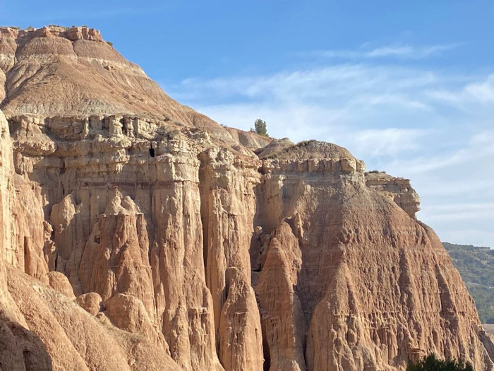
The route begins at the shores of the Negratín Reservoir and follows a well-marked trail through pine forests, dry riverbeds, and floodplains, offering views of Cerro Jabalcón and the geological formations known as the Cathedrals of the Geopark. It includes sections with a risk of falls and vertigo, especially in the Doblas Ravine. The route combines ascents and descents along tracks and trails through pine, almond, and tamarisk trees, finishing back near the shoreline.
The Granada Geopark is a unique territory renowned for its spectacular landscapes and immense geological value. It covers a large part of the northern regions of the province and has been shaped by millions of years of natural processes that have created canyons, badlands, gullies, gorges, and intensely colored clay formations. Its natural viewpoints offer breathtaking panoramic views. Among its most emblematic sites are the Cathedrals of the Geopark with their spectacular eroded walls.
| Distance | 13.453 km |
| Duration | 4 hours 1 minutes GPX ------ 4 hours 26 mins (Naismith) |
| Total Climb | 426 m |
| Highest Point | 825 m |
| Weather Link | Click here |
Meeting Point: Embalse de Negratín: Parking
See map full screen Click here
Note: You can choose different types of maps using the drop down (top right) EG ArcGis Ariel is satelliteSorry we do not allow download of the gpx file of this walk because our group suffered a takeover by the weasly walkers. Click here if you would like to know what a walking group takeover is.
This page has been seen 1107 times since - 17th November 2025