
This circular route begins and ends in Béznar in the Valle de Lecrín. The route is 12.49 km long, has an elevation of 409 m and takes about 4 hours to complete.
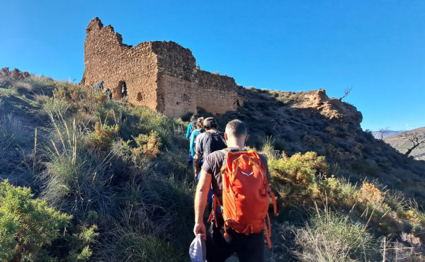
This route explores several towns in the Valle de Lecrín and also visits the Mondújar Castle. The route begins in Béznar and from here we walk up, passing under the motorway, to the Castillo de Mondújar with impressive views of the surrounding area. This is the highest point of the route at 860 meters. From here, we first walk down to the town of Mondújar, then through to Talará before walking through the centre of Chite. The route continues down to the Presa de Béznar before returning to Béznar and the starting point.
Note: The end part of this walk is only possible if the water level on the reservoir is low. In late 2023 the level is very low and it is easy to walk across. If there are very big rains in the future and the water level is very high then it may become impassible. There used to be a walkway around the end of the reservoir but it has fallen down.
| Distance | 13.054 km |
| Duration | 5 hours 5 minutes GPX ------ 4 hours 17 mins (Naismith) |
| Total Climb | 409 m |
| Highest Point | 876 m |
| Weather Link | Click here |
Meeting Point: Béznar: meeting point
See map full screen Click here
Note: You can choose different types of maps using the drop down (top right) EG ArcGis Ariel is satelliteSorry we do not allow download of the gpx file of this walk because our group suffered a takeover by the weasly walkers. Click here if you would like to know what a walking group takeover is.
This page has been seen 1714 times since - 30th November 2023